Moe - Woods Point
#Bike
- Distance: 109.2 Km
- Elevation gain: 3,295 m
- Maximum elevation: 1,165 m
- Elevation loss: 2,680 m
- Minimum elevation: 52 m
Interactive map
GPS track profile
About this GPS track
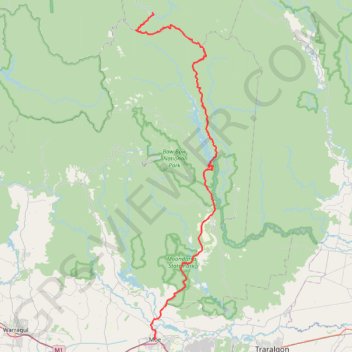
Name: Moe - Woods Point GPS track, route, trail
Start: George Street, Moe, City of Latrobe, Victoria, 3825, Australia (-38.17633 146.26099)
End: Warburton-Matlock Road, Woods Point, Shire of Mansfield, Victoria, Australia (-37.57042 146.25507)
Coordinates: -38.17634 146.21639 -37.57042 146.40765
Other GPS tracks
Click on a GPS track to view route, its statistics and profile.
Traralgon - Walhalla - Woods Point
Australia > Victoria > Traralgon
#Bike
Distance: 124.6 Km • Elevation gain: 4,258 m • Maximum elevation: 1,165 m