Chinatown - Singapore
Interactive map
GPS track profile
About this GPS track
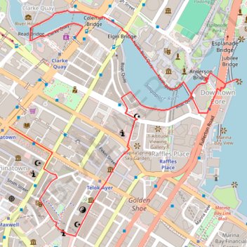
Name: Chinatown - Singapore GPS track, route, trail
Coordinates: 1.27976 103.84409 1.29024 103.85470
Topography: Singapore topographic map
Other GPS tracks
Click on a GPS track to view route, its statistics and profile.
Directions from Duck Tour Ramp to Marina Boulevard, Singapore
Singapore > Central > Singapore
Distance: 105.3 Km • Elevation gain: 812 m • Maximum elevation: 51 m
Kualanamu International Airport to Jakarta, Indonesia
Indonésie > Sumatra du Nord > Deli Serdang > Beringin
Distance: 1,809.2 Km • Elevation gain: 10,977 m • Maximum elevation: 125 m