Import a GPX file

Québec - Montréal - Saint-Laurent River - Lake Ontario - Niagara Falls

#Bike #Ontario

  • Distance: 1,078.4 Km
  • Elevation gain: 4,804 m
  • Maximum elevation: 209 m
  • Elevation loss: 4,632 m
  • Minimum elevation: -1 m

Interactive map

GPS track profile

About this GPS track
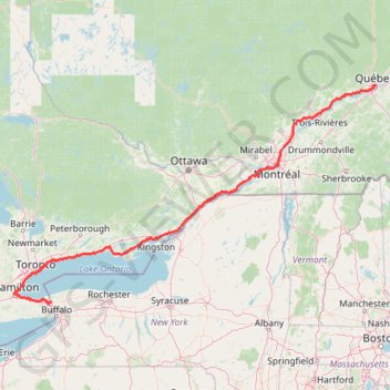
Other GPS tracks

Click on a GPS track to view route, its statistics and profile.

Montréal - New York

Canada > Quebec > Urban agglomeration of Montreal > Montreal

#Bike #Montréal #NewYork

Distance: 637.6 Km • Elevation gain: 4,860 m • Maximum elevation: 301 m

Bike ride to 50 point and back

Canada > Ontario > Niagara Region > Grimsby

Distance: 31.7 Km • Elevation gain: 237 m • Maximum elevation: 209 m

Webster Park

United States > New York > Monroe County > Town of Webster

Distance: 2.9 Km • Elevation gain: 22 m • Maximum elevation: 100 m

Bike ride losely along greenbelt trail

Canada > Ontario > Niagara Region > Grimsby

Distance: 24.5 Km • Elevation gain: 200 m • Maximum elevation: 206 m

Midhurst Trail

Canada > Ontario > Simcoe County > Springwater > Midhurst

Simcoe County Forest. #Hike #MTB #Snowshoes #Loop #Simcoe

Distance: 8.4 Km • Elevation gain: 92 m • Maximum elevation: 246 m

North Tripyramid, Middle Tripyramid and South Tripyramid

United States > New Hampshire > Grafton County

Hike to North Tripyramid, Middle Tripyramid and South Tripyramid via Pine Bend Brook Trail and Mount Tripyramid Trail in the Sandwich Range Wilderness and the White Mountain National Forest. #Hike #Mountain #Nature #Forest

Distance: 15.4 Km • Elevation gain: 1,020 m • Maximum elevation: 1,244 m

Allen Mountain

United States > New York > Essex County > Town of Newcomb

Hike / snowshoes from East River Parking to Allen Mountain via East River Trail, Hudson River, Lake Jimmy, Lake Sally, Allen Mountain Trail and Allen Lookout North in the High Peaks Wilderness and the Adirondack Park. #Hike #Snowshoes #Mountain #Nature #Forest #Lake #River #Park #Wilderness #Adirondack

Distance: 28.7 Km • Elevation gain: 1,060 m • Maximum elevation: 1,302 m

Toronto Cycling

Canada > Ontario > Toronto

Distance: 39.0 Km • Elevation gain: 356 m • Maximum elevation: 124 m

Mount Washington, Lion Head and Tuckerman Ravine Loop

United States > New Hampshire > Coos County

Loop hike from Pinkham Notch to Mount Washington via Tuckerman Ravine Trail, Crystal Cascades Falls and Lion Head Trail in the Pinkham Notch Scenic Area, the Mount Washington State Park and the White Mountain National Forest. #Hike #Loop #Mountain #Nature #Forest #Falls #Park

Distance: 12.6 Km • Elevation gain: 1,325 m • Maximum elevation: 1,911 m

Albion and Buttermilk Falls via Mountain Brow Side Trail

Canada > Ontario > Hamilton

#Hike #Loop

Distance: 3.7 Km • Elevation gain: 74 m • Maximum elevation: 187 m

Simcoe County Forest - Foster Tract

Canada > Ontario > Simcoe County > Essa

#Hike #Loop

Distance: 3.9 Km • Elevation gain: 17 m • Maximum elevation: 228 m

Parc Maisonneuve et jardin botanique de Montréal

Canada > Québec > Agglomération de Montréal > Montréal

Randonnée / course à pied en boucle par le parc Maisonneuve et jardin botanique de Montréal. #Randonnée #Course #Boucle #Parc #Nature #Forêt #Ville

Distance: 10.6 Km • Elevation gain: 62 m • Maximum elevation: 68 m

Black Snout and Mount Shaw Loop

United States > New Hampshire > Carroll County > Tuftonboro

Hike to Mount Shaw via Mount Shaw Trail, Italian Trail, Big Ball Mountain, Black Snout Trail and High Ridge Trail. #Hike #Loop #Mountain #Nature #Forest

Distance: 12.2 Km • Elevation gain: 739 m • Maximum elevation: 895 m

Noonmark Mountain

United States > New York > Essex County > Town of Keene

Hike from Round Pond to Noonmark Mountain via Dix Trail and Felix Adler Trail in the High Peaks Wilderness and the Adirondack Park. #Hike #Mountain #Nature #Lake #Forest #Park

Distance: 10.6 Km • Elevation gain: 651 m • Maximum elevation: 1,055 m

Mount Liberty and Mount Flume

United States > New Hampshire > Grafton County > Lincoln

Hike to Mount Liberty and Mount Flume via Franconia Notch Bike Path, Liberty Spring Trail and Franconia Ridge Trail in the Franconia Notch State Park and the White Mountain National Forest. #Hike #Mountain #Nature #Forest #Park

Distance: 14.3 Km • Elevation gain: 1,181 m • Maximum elevation: 1,329 m

Mississauga River Loop

Canada > Ontario > Peterborough County > Trent Lakes

Kawartha Highlands Signature Site. #Hike #Snowshoes #Loop #Kawartha

Distance: 1.6 Km • Elevation gain: 8 m • Maximum elevation: 251 m

Boucle de la Forêt Boucher

Canada > Québec > Gatineau

Forêt Boucher. #Randonnée #Boucle

Distance: 5.0 Km • Elevation gain: 24 m • Maximum elevation: 123 m

Saddleback Mountain

United States > New York > Essex County > Town of Keene

Hike from Garden Parking Area to Saddleback Mountain via Phelps Trail, Orebed Brook Trail and State Range Trail in the Johns Brook Primitive Area, the High Peaks Wilderness and the Adirondack Park. #Hike #Mountain #Nature #Forest #River #Park #Wilderness

Distance: 24.5 Km • Elevation gain: 1,085 m • Maximum elevation: 1,361 m

Randonnee parc mauricie sentier des cascades

Canada > Québec > Maskinongé (MRC) > Shawinigan

Randonnée en boucle depuis Saint-Roch-de-Mékinac. #Randonnée #Boucle

Distance: 3.0 Km • Elevation gain: 78 m • Maximum elevation: 280 m

Toronto - Martin Goodman Trail - Waterfront Trail

Canada > Ontario > Old Toronto

Lake Ontario. #Bike #Toronto #Ontario

Distance: 15.0 Km • Elevation gain: 74 m • Maximum elevation: 87 m

Mont Chauve par le ruisseau David

Canada > Québec > Memphrémagog > Orford

Parc national du Mont-Orford. #Randonnée #Raquettes #Boucle #MontOrford

Distance: 12.8 Km • Elevation gain: 542 m • Maximum elevation: 587 m

Boucle dans le Parc national du Mont-Saint-Bruno

Canada > Québec > Agglomération de Longueuil > Saint-Bruno-de-Montarville

Randonnée en boucle par le Chemin Saint-Gabriel, le Lac Seigneurial et le Lac du Moulin. #Randonnée #Boucle #Parc #Nature #Forêt #Lac

Distance: 7.5 Km • Elevation gain: 101 m • Maximum elevation: 113 m

Mount Hale

United States > New Hampshire > Grafton County > Bethlehem

Hike to Mount Hale via Hale Brook Trail in the White Mountain National Forest. #Hike #Mountain #Nature #Forest

Distance: 6.7 Km • Elevation gain: 679 m • Maximum elevation: 1,224 m

Base

Canada > Québec > Agglomération de Montréal > Montréal

Objectif 139 bpm pendant 46 minutes.

Distance: 10.5 Km • Elevation gain: 43 m • Maximum elevation: 60 m

Trois-Rivières - Québec

Canada > Quebec > Trois-Rivières

#Bike

Distance: 138.5 Km • Elevation gain: 838 m • Maximum elevation: 108 m

Mount Field, Mount Willey, Mount Avalon and Mount Tom Loop

United States > New Hampshire > Coos County > Carroll

Loop hike from Sako Lake via Avalon Trail, Mount Avalon, Mount Field, Willey Range Trail, Mount Willey, Mount Tom Spur, Mount Tom and A-Z Trail in the White Mountain National Forest. #Hike #Loop #Mountain #Nature #Forest #Lake

Distance: 15.2 Km • Elevation gain: 1,021 m • Maximum elevation: 1,299 m

Mount Adams and Mount Madison Loop

United States > New Hampshire > Coos County > Randolph

Loop hike from Appalachia Trailhead to Mount Adams and Mount Madison via Airline Trail, Gulfside Trail, Madison Spring Hut, Osgood Trail, Watson Path and Valley Way in the Whites Mountains National Forest. #Hike #Loop #Mountain #Nature #Forest

Distance: 13.8 Km • Elevation gain: 1,511 m • Maximum elevation: 1,754 m

Mount Waumbek and Mount Starr King

United States > New Hampshire > Coos County > Jefferson

Hike to Mount Waumbek and Mount Starr King via Starr King Trail and Kilkenny Ridge Trail in the White Mountain National Forest. #Hike #Mountain #Nature #Forest

Distance: 10.8 Km • Elevation gain: 819 m • Maximum elevation: 1,208 m

Blueberry Mountain

United States > New Hampshire > Grafton County > Benton > Boutin Corner

Hike to Blueberry Mountain via Blueberry Mountain Trail in the White Mountain National Forest. #Hike #Mountain #Forest #Nature

Distance: 5.6 Km • Elevation gain: 321 m • Maximum elevation: 802 m

Mount Marcy, Mount Skylight and Gray Peak

United States > New York > Essex County > Town of Keene > Town of Newcomb

Return hike from Mount Marcy to Heart Lake via Mount Marcy Trail, Schofield Cobble, Four Corners, Skylight Trail, Lake Tear of the Clouds, Gray Peak Trail, Van Hoevenberg Trail, Indian Falls and Marcy Dam Pond in the High Peaks Wilderness and the Adirondack Park. #Hike #Mountain #Nature #Forest #Lake #Falls #Park #Wilderness

Distance: 17.9 Km • Elevation gain: 607 m • Maximum elevation: 1,612 m

Mount Colden Loop

United States > New York > Essex County

Loop hike from Heart Lake to Mount Colden via Van Hoevenberg Trail, Marcy Dam Pond, Avalanche Pass Trail, Avalanche Pass, Avalanche Lake, Lake Colden, Mount Colden Trail, L. Morgan Porter Trail, Lake Arnold and Lake Arnold Trail in the High Peaks Wilderness and the Adirondack Park. #Hike #Loop #Mountain #Lake #Forest #Nature #Park

Distance: 21.7 Km • Elevation gain: 1,000 m • Maximum elevation: 1,415 m

Mont-Tremblant

Canada > Québec > Les Laurentides > Mont-Tremblant

Randonnée en boucle depuis Mont-Tremblant. #Randonnée #Boucle

Distance: 15.1 Km • Elevation gain: 798 m • Maximum elevation: 923 m

Mount Skylight

United States > New York > Essex County

Hike to Mount Skylight via Adirondack Loj Road, Heart Lake, Van Hoevenberg Trail, Marcy Dam, Avalanche Pass Trail, Avalanche Camp, Lake Arnold Trail, Lake Arnold, Mount Marcy Trail, Lake Tear of the Clouds, Four Corners and Skylight Trail in the High Peaks Wilderness and the Adirondack Park. #Hike #Mountain #Nature #Forest #Lake

Distance: 33.0 Km • Elevation gain: 1,295 m • Maximum elevation: 1,492 m

Sentier Mékinac

Canada > Québec > Shawinigan

Parc national de la Mauricie. #Randonnée #Boucle #Mauricie

Distance: 10.2 Km • Elevation gain: 301 m • Maximum elevation: 265 m

Mount Crawford

United States > New Hampshire > Carroll County > Hart's Location > Notchland

Hike from Saco River to Mount Crawford via Davis Path and Mount Crawford Spur in the Presidential Range-Dry River Wilderness. #Hike #Mountain #River #Nature #Forest #Wilderness

Distance: 7.3 Km • Elevation gain: 629 m • Maximum elevation: 931 m

Bondcliff

United States > New Hampshire > Grafton County > Lincoln

Hike from Lincoln Woods Trailhead to Bondcliff via East Branch Pemigewasset River, Lincoln Woods Trail and Bondcliff Trail in the Pemigewasset Wilderness. #Hike #Mountain #Nature #Forest #River #Wilderness

Distance: 29.0 Km • Elevation gain: 1,002 m • Maximum elevation: 1,281 m

Toronto Loop

Canada > Ontario > Old Toronto

#Hike #Loop #Toronto #Ontario

Distance: 14.4 Km • Elevation gain: 207 m • Maximum elevation: 124 m

Orford, QC, sentier du ruisseau des chènes

Canada > Québec > Memphrémagog > Austin

Randonnée en aller-retour depuis Austin. #Randonnée

Distance: 10.1 Km • Elevation gain: 751 m • Maximum elevation: 840 m

Mount Lafayette Loop

United States > New Hampshire > Grafton County > Lincoln

White Mountain National Forest. Stairs Falls, Cloudland Falls, Dry Creek, Franconia Ridge, Greenleaf Hut. #Hike #Snowshoes #Mountain #Forest #Waterfall #River #Nature

Distance: 13.5 Km • Elevation gain: 1,138 m • Maximum elevation: 1,582 m

Montréal - Westmount

Canada > Quebec > Urban agglomeration of Montreal > Montreal

#Bike #Montréal

Distance: 13.7 Km • Elevation gain: 33 m • Maximum elevation: 60 m

Mizzy Lake Trail

Canada > Ontario > Nipissing District > Unorganized South Nipissing

Algonquin Provincial Park. #Hike #Loop #Mizzy #Algonquin

Distance: 11.8 Km • Elevation gain: 159 m • Maximum elevation: 464 m

Oka - Montréal

Canada > Quebec > Deux-Montagnes (MRC) > Oka

#Bike #Montréal

Distance: 65.3 Km • Elevation gain: 268 m • Maximum elevation: 51 m

Old Nipissing Ghost Trail

Canada > Ontario > Parry Sound District > Unorganized Centre Parry Sound

#Bike #Nipissing

Distance: 49.6 Km • Elevation gain: 562 m • Maximum elevation: 386 m

Salaberry-de-Valleyfield - Montréal

Canada > Quebec > Beauharnois-Salaberry > Salaberry-de-Valleyfield

#Bike

Distance: 89.9 Km • Elevation gain: 363 m • Maximum elevation: 70 m

Lyon Mountain Loop

United States > New York > Clinton County > Town of Dannemora > Lyon Mountain

Loop hike to Lyon Mountain Fire Tower via Lyon Mountain Trail and Old Lyon Mountain Trail in the Chazy Highlands State Forest and the Adirondacks Park. #Hike #Loop #Mountain #Nature #Forest #Park

Distance: 8.6 Km • Elevation gain: 572 m • Maximum elevation: 1,156 m

Bilberry Creek Ravine Loop

Canada > Ontario > Ottawa

#Hike #Snowshoes #Run #Loop

Distance: 1.9 Km • Elevation gain: 13 m • Maximum elevation: 88 m

Mount Cabot

United States > New Hampshire > Coos County > Berlin

Hike to Mount Cabot via York Pond Trail, Bunnell Notch Trail, Bunnell Notch, Killkenny Ridge Trail, Bunnell Rock and Mount Cabot Cabin in the White Mountain National Forest. #Hike #Mountain #Forest #Nature

Distance: 14.8 Km • Elevation gain: 850 m • Maximum elevation: 1,260 m

Mount Marcy, Table Top and Phelps Mountain

United States > New York > Essex County

Hike from Heart Lake to Mount Marcy, Table Top and Phelps Mountain via Van Hoevenberg Trail, Marcy Dam, Phelps Mountain Trail, Indian Falls and Tabletop Mountain Trail in the High Peaks Wilderness and the Adirondacks Park. #Hike #Mountain #Nature #Forest #Lake #Falls #River #Wilderness #Park

Distance: 29.5 Km • Elevation gain: 1,679 m • Maximum elevation: 1,612 m

Lake Ontario Waterfront Trail

Canada > Ontario > Durham Region > Pickering

#Hike #Bike #Ontario

Distance: 80.7 Km • Elevation gain: 598 m • Maximum elevation: 129 m

Bendor and Graves Tract - West Track

Canada > Ontario > York Region > East Gwillimbury

York Regional Forest. #Hike #MTB #Loop

Distance: 6.3 Km • Elevation gain: 77 m • Maximum elevation: 297 m