Anglesea - Aireys Inlet
Great Otway National Park. #Hike #Loop #GreatOtway
- Distance: 24.8 Km
- Elevation gain: 462 m
- Maximum elevation: 99 m
- Elevation loss: 462 m
- Minimum elevation: 0 m
- Moving time: 6 h 49 m
- Moving speed: 3.6 Km/h
- Maximum speed: 38.8 Km/h
- Total time: 7 h 23 m
- Global speed: 3.4 Km/h
- Date: 18/01/2020
Interactive map
GPS track profile
About this GPS track
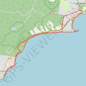
Name: Anglesea - Aireys Inlet GPS track, route, trail
Start: Surf Coast Walk, Anglesea, Surf Coast Shire, Victoria, 3230, Australia (-38.41043 144.18742)
End: Surf Coast Walk, Anglesea, Surf Coast Shire, Victoria, 3230, Australia (-38.41019 144.18708)
Coordinates: -38.46708 144.10519 -38.41011 144.19042
Other GPS tracks
Click on a GPS track to view route, its statistics and profile.
Surf Coast Walk
Australia > Victoria > Torquay
Bass Strait. #Hike
Distance: 34.0 Km • Elevation gain: 607 m • Maximum elevation: 111 m