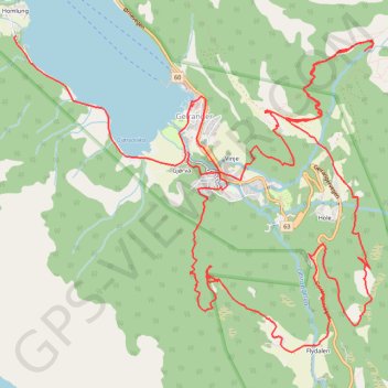
Homlong - Geiranger
Randonnée pédestre. #Randonnée
- Distance: 16.3 Km
- Elevation gain: 1,290 m
- Maximum elevation: 547 m
- Elevation loss: 1,296 m
- Minimum elevation: -1 m
- Moving time: 5 h 6 m
- Moving speed: 3.2 Km/h
- Maximum speed: 39.3 Km/h
- Total time: 8 h 52 m
- Global speed: 1.8 Km/h
- Date: 17/06/2006
Interactive map
GPS track profile
About this GPS track
Name: Homlong - Geiranger GPS track, route, trail
End: Homlungsvegen, Gjørva, Geiranger, Stranda, Møre og Romsdal, 6216, Norvège (62.09822 7.20493)
Coordinates: 62.08488 7.18032 62.10592 7.23137
Other GPS tracks
Click on a GPS track to view route, its statistics and profile.
Geiranger to Keipane
Norvège > Møre og Romsdal > Geiranger
Randonnée en aller-retour depuis Geiranger. #Randonnée
Distance: 19.6 Km • Elevation gain: 1,708 m • Maximum elevation: 1,302 m
Geiranger
Norvège > Møre og Romsdal > Geiranger
Randonnée pédestre. #Randonnée
Distance: 7.2 Km • Elevation gain: 211 m • Maximum elevation: 125 m