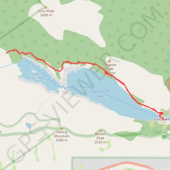
Upper Echo Lake and Lower Echo Lake
Hike from Echo Lake to Upper Echo Lake and Lower Echo Lake via Echo Pass Viewpoint and Pacific Crest National Scenic Trail (PCT) in the Lake Tahoe Basin Management Unit. #Hike #Lake #Mountain #Nature #Forest #PCT #Overlook
- Distance: 9.6 Km
- Elevation gain: 273 m
- Maximum elevation: 2,327 m
- Elevation loss: 270 m
- Minimum elevation: 2,264 m
- Moving time: 4 h 10 m
- Moving speed: 2.3 Km/h
- Maximum speed: 4.2 Km/h
- Total time: 5 h 51 m
- Global speed: 1.6 Km/h
- Date: 14/08/2019
Interactive map
GPS track profile
About this GPS track
Name: Upper Echo Lake and Lower Echo Lake GPS track, route, trail
Start: Echo Lakes Road, Echo Lake, El Dorado County, California, 95721, United States (38.83457 -120.04408)
End: Echo Lakes Road, Echo Lake, El Dorado County, California, 95721, United States (38.83445 -120.04378)
Coordinates: 38.83430 -120.08339 38.84805 -120.04375
Other GPS tracks
Click on a GPS track to view route, its statistics and profile.
Chester - Walker
États-Unis d'Amérique > Californie > Plumas County > Chester
Vélo. En aller simple entre Chester et Walker. #Vélo
Distance: 383.8 Km • Elevation gain: 6,088 m • Maximum elevation: 2,541 m