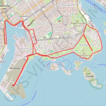
Route and drinking stations_10,55 km loop
This is track no: 1
- Distance: 10.8 Km
- Elevation gain: 119 m
- Maximum elevation: 20 m
- Elevation loss: 119 m
- Minimum elevation: 0 m
Interactive map
GPS track profile
About this GPS track
Name: Route and drinking stations_10,55 km loop GPS track, route, trail
Coordinates: 60.14822 24.92170 60.16200 24.96293
Other GPS tracks
Click on a GPS track to view route, its statistics and profile.
Stage 1: Arctic Ocean to Väylä — European Divide Trail
Distance: 2,785.0 Km • Elevation gain: 23,823 m • Maximum elevation: 722 m