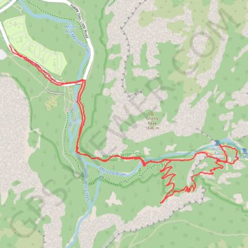
Vernal Fall and Clark Point Loop
Loop hike to Vernal Fall and Clark Point via Happy Isles Bridge, Merced River, John Muir Trail and Mist Trail in the Yosemite National Park. #Hike #Loop #Nature #Falls #River #Forest #Mountain #Yosemite #Park
- Distance: 9.4 Km
- Elevation gain: 806 m
- Maximum elevation: 1,699 m
- Elevation loss: 801 m
- Minimum elevation: 1,221 m
- Moving time: 2 h 18 m
- Moving speed: 4.1 Km/h
- Maximum speed: 16.5 Km/h
- Total time: 2 h 33 m
- Global speed: 3.7 Km/h
- Date: 20/09/2019
Interactive map
GPS track profile
About this GPS track
Name: Vernal Fall and Clark Point Loop GPS track, route, trail
Coordinates: 37.72256 -119.56570 37.73573 -119.54148
Other GPS tracks
Click on a GPS track to view route, its statistics and profile.
Nevada Fall Loop
United States > California > Mariposa County > Curry Village
Loop hike from Curry Village to Nevada Fall via Happy Isles Bridge, Merced River, John Muir Trail, Mist Trail, Vernal Fall and Clark Point in the Yosemite National Park. #Hike #Loop #Mountain #River #Falls #Nature #Forest #Park #Yosemite
Distance: 14.3 Km • Elevation gain: 1,153 m • Maximum elevation: 1,849 m
Vernal and Nevada Falls Loop
United States > California > Mariposa County > Curry Village
Distance: 11.8 Km • Elevation gain: 910 m • Maximum elevation: 1,846 m
JMT1-16847633
États-Unis d'Amérique > Californie > Inyo County
Distance: 401.4 Km • Elevation gain: 15,190 m • Maximum elevation: 4,385 m
Walker - Auberry
États-Unis d'Amérique > Californie > Mono County > Walker
Vélo. En aller simple entre Walker et Auberry. #Vélo
Distance: 354.0 Km • Elevation gain: 6,633 m • Maximum elevation: 3,039 m