Wandong loop
- Distance: 11.2 Km
- Elevation gain: 427 m
- Maximum elevation: 473 m
- Elevation loss: 427 m
- Minimum elevation: 341 m
- Moving time: 50 m 29 s
- Moving speed: 13.3 Km/h
- Maximum speed: 41.8 Km/h
- Total time: 1 h 6 m
- Global speed: 10.1 Km/h
- Date: 27/03/2022
Interactive map
GPS track profile
About this GPS track
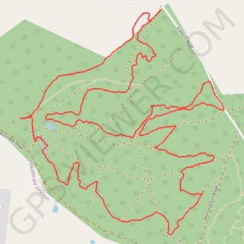
Name: Wandong loop GPS track, route, trail
Start: Scanlons Road, Wandong, Shire of Mitchell, Victoria, 3758, Australia (-37.35437 145.05639)
End: Scanlons Road, Wandong, Shire of Mitchell, Victoria, 3758, Australia (-37.35366 145.05714)
Coordinates: -37.36991 145.04438 -37.35366 145.06288
Other GPS tracks
Click on a GPS track to view route, its statistics and profile.
Tallarook - Eildon - Hurstbridge
Australia > Victoria > Tallarook
#Bike
Distance: 278.8 Km • Elevation gain: 4,897 m • Maximum elevation: 868 m