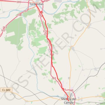
SE26-MedinaDC-Tordesillas
Total: 24.8km
- Distance: 24.8 Km
- Elevation gain: 142 m
- Maximum elevation: 801 m
- Elevation loss: 166 m
- Minimum elevation: 668 m
Interactive map
GPS track profile
About this GPS track
Name: SE26-MedinaDC-Tordesillas GPS track, route, trail
End: Plaza Mayor, Tordesillas, Valladolid, Castille-et-León, 47100, Espagne (41.50086 -5.00041)
Coordinates: 41.30809 -5.00128 41.50086 -4.91504
Other GPS tracks
Click on a GPS track to view route, its statistics and profile.
EuroVelo 1 (Spain)
Espagne > Andalousie > Côte occidentale > Ayamonte
Distance: 1,355.6 Km • Elevation gain: 14,587 m • Maximum elevation: 1,320 m
Southern section — European Divide Trail
France > Auvergne-Rhône-Alpes > Drôme > Valence
Distance: 2,423.8 Km • Elevation gain: 42,375 m • Maximum elevation: 2,005 m
Eurovelo 01 Spain + Portugal
France > Nouvelle-Aquitaine > Pyrénées-Atlantiques > Hendaye
Distance: 3,107.2 Km • Elevation gain: 30,592 m • Maximum elevation: 1,503 m
Stage 26: Valence to Saint-Jean-de-Fos — European Divide Trail
France > Auvergne-Rhône-Alpes > Drôme > Valence
Distance: 2,423.8 Km • Elevation gain: 42,375 m • Maximum elevation: 2,005 m
EuroVelo 1 (Spain)
Espagne > Andalousie > Côte occidentale > Ayamonte > Pozo del Camino > Fotea
Distance: 1,349.7 Km • Elevation gain: 13,641 m • Maximum elevation: 1,320 m
De Villeneuve-sur-Lot à Guimarães
France > Nouvelle-Aquitaine > Lot-et-Garonne > Villeneuve-sur-Lot
Distance: 2,024.3 Km • Elevation gain: 22,121 m • Maximum elevation: 1,339 m
Etape 6 Briviesca - Alaejos
Espagne > Castille-et-León > Briviesca
Distance: 247.3 Km • Elevation gain: 2,189 m • Maximum elevation: 976 m