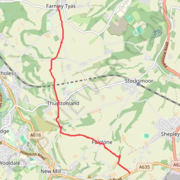
Gate Foot to Farnley Tyas via Thurstonland
Gate Foot - Snowgate Head - Fulstone - Biggin - Top of the Bank - Thurstonland - Top of the Hill - Farnley Tyas
- Distance: 5.8 Km
- Elevation gain: 142 m
- Maximum elevation: 288 m
- Elevation loss: 169 m
- Minimum elevation: 202 m
- Moving time: 1 h 48 m
- Moving speed: 3.2 Km/h
- Maximum speed: 5.7 Km/h
- Total time: 2 h 17 m
- Global speed: 2.5 Km/h
- Date: 25/04/2024
Interactive map
GPS track profile
About this GPS track
Name: Gate Foot to Farnley Tyas via Thurstonland GPS track, route, trail
Coordinates: 53.57459 -1.75583 53.61108 -1.72628
Other GPS tracks
Click on a GPS track to view route, its statistics and profile.
Track 2024-05-10 11:49 Kirklees Way from Gate Foot to Hepworth (KW)(HVCW)
United Kingdom > England > Kirklees > Fulstone > Snowgate Head
Snowgate Head - Gate Foot - Jackson Bridge - Hepworth
Distance: 4.7 Km • Elevation gain: 137 m • Maximum elevation: 334 m