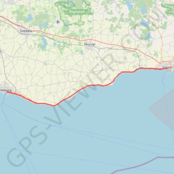
Sydkustleden
- Distance: 47.1 Km
- Elevation gain: 150 m
- Maximum elevation: 13 m
- Elevation loss: 148 m
- Minimum elevation: -1 m
Interactive map
GPS track profile
About this GPS track
Name: Sydkustleden GPS track, route, trail
End: Kontinentgatan, Trelleborg, Trelleborgs kommun, Comté de Scanie, 231 42, Suède (55.37235 13.15857)
Coordinates: 55.33895 13.15857 55.42746 13.82390
Other GPS tracks
Click on a GPS track to view route, its statistics and profile.
NC4k_22_05
Suède > Comté de Scanie > Trelleborg
Distance: 359.1 Km • Elevation gain: 2,444 m • Maximum elevation: 283 m