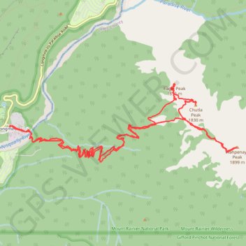
New Track 9/25/22 6:30:32 AM
- Distance: 18.0 Km
- Elevation gain: 1,398 m
- Maximum elevation: 1,879 m
- Elevation loss: 1,398 m
- Minimum elevation: 846 m
- Moving time: 5 h 38 m
- Moving speed: 3.2 Km/h
- Maximum speed: 15.4 Km/h
- Total time: 9 h 17 m
- Global speed: 1.9 Km/h
- Date: 25/09/2022
Interactive map
GPS track profile
About this GPS track
Name: New Track 9/25/22 6:30:32 AM GPS track, route, trail
Start: Forest Road 012, Longmire, Pierce County, Washington, United States (46.74974 -121.81190)
End: Forest Road 012, Longmire, Pierce County, Washington, United States (46.74983 -121.81201)
Coordinates: 46.74495 -121.81203 46.75570 -121.76672
Other GPS tracks
Click on a GPS track to view route, its statistics and profile.
Northern part of the Pacific Crest Trail (PCT)
United States > Oregon > Klamath County
Hike on the Pacific Crest National Scenic Trail from Crater Lake to Canada Border through Oregon and Washington along the Sierra Nevada and Cascade mountain ranges. #Hike #Mountain #SierraNevada #Cascade #Nature #Forest #Park #PCT
Distance: 1,198.3 Km • Elevation gain: 44,308 m • Maximum elevation: 2,307 m