The High Coast Trail
- Distance: 124.9 Km
- Elevation gain: 3,028 m
- Maximum elevation: 266 m
- Elevation loss: 2,948 m
- Minimum elevation: 0 m
Interactive map
GPS track profile
About this GPS track
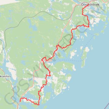
Name: The High Coast Trail GPS track, route, trail
Start: Y 824, Nora distrikt, Kramfors kommun, Comté de Västernorrland, 872 94, Suède (62.80394 17.95132)
Coordinates: 62.78679 17.94662 63.28804 18.70326
Other GPS tracks
Click on a GPS track to view route, its statistics and profile.
Stage 1: Arctic Ocean to Väylä — European Divide Trail
Distance: 2,785.0 Km • Elevation gain: 23,823 m • Maximum elevation: 722 m