Tour de Campomoro - circuit littoral
Interactive map
GPS track profile
About this GPS track
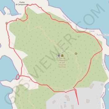
Name: Tour de Campomoro - circuit littoral GPS track, route, trail
Coordinates: 41.63668 8.80417 41.64112 8.80983
Other GPS tracks
Click on a GPS track to view route, its statistics and profile.
1 LUCENA - MONTPELLIER
Distance: 2,964.4 Km • Elevation gain: 29,500 m • Maximum elevation: 1,048 m
1 LUCENA - MONTPELLIER
Espagne > Andalousie > Lucena
Distance: 2,964.4 Km • Elevation gain: 29,500 m • Maximum elevation: 1,048 m
Ajaccio - Bastia par le sud
France > Corse > Corse-du-Sud > Ajaccio
Vélo. En aller simple entre Ajaccio et Bastia. #Vélo
Distance: 337.2 Km • Elevation gain: 4,747 m • Maximum elevation: 556 m
TG6ak
France > Corse > Haute-Corse > Bastia
tour de corse vélo de voyage trace en préparation
Distance: 811.0 Km • Elevation gain: 22,311 m • Maximum elevation: 1,478 m