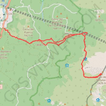
Peñalara desde Valsain
Randonnée en boucle depuis La Pradera de Navalhorno. #Randonnée #Boucle
- Distance: 19.9 Km
- Elevation gain: 1,226 m
- Maximum elevation: 2,421 m
- Elevation loss: 1,226 m
- Minimum elevation: 1,205 m
- Moving time: 5 h 56 m
- Moving speed: 3.3 Km/h
- Maximum speed: 6.4 Km/h
- Total time: 7 h 27 m
- Global speed: 2.7 Km/h
- Date: 11/12/2014
Interactive map
GPS track profile
About this GPS track
Name: Peñalara desde Valsain GPS track, route, trail
Coordinates: 40.84813 -4.02047 40.87293 -3.95577
Other GPS tracks
Click on a GPS track to view route, its statistics and profile.
EuroVelo 1 (Spain)
Espagne > Andalousie > Côte occidentale > Ayamonte
Distance: 1,355.6 Km • Elevation gain: 14,587 m • Maximum elevation: 1,320 m
Southern section — European Divide Trail
France > Auvergne-Rhône-Alpes > Drôme > Valence
Distance: 2,423.8 Km • Elevation gain: 42,375 m • Maximum elevation: 2,005 m
Eurovelo 01 Spain + Portugal
France > Nouvelle-Aquitaine > Pyrénées-Atlantiques > Hendaye
Distance: 3,107.2 Km • Elevation gain: 30,592 m • Maximum elevation: 1,503 m
1 LUCENA - MONTPELLIER
Distance: 2,964.4 Km • Elevation gain: 29,500 m • Maximum elevation: 1,048 m
1 LUCENA - MONTPELLIER
Espagne > Andalousie > Lucena
Distance: 2,964.4 Km • Elevation gain: 29,500 m • Maximum elevation: 1,048 m
Stage 26: Valence to Saint-Jean-de-Fos — European Divide Trail
France > Auvergne-Rhône-Alpes > Drôme > Valence
Distance: 2,423.8 Km • Elevation gain: 42,375 m • Maximum elevation: 2,005 m
EuroVelo 1 (Spain)
Espagne > Andalousie > Côte occidentale > Ayamonte > Pozo del Camino > Fotea
Distance: 1,349.7 Km • Elevation gain: 13,641 m • Maximum elevation: 1,320 m
Alcalá de Henares - Cercedilla
Espagne > Communauté de Madrid > Alcalá de Henares
En aller simple entre Alcalá de Henares et Cercedilla.
Distance: 249.5 Km • Elevation gain: 4,441 m • Maximum elevation: 1,860 m