Yurol State Forest Loop
Loop hike / run in the Yurol State Forest. #Hike #Run #Loop #Forest #Nature
- Distance: 12.8 Km
- Elevation gain: 144 m
- Maximum elevation: 128 m
- Elevation loss: 145 m
- Minimum elevation: 94 m
- Moving time: 1 h 27 m
- Moving speed: 8.8 Km/h
- Maximum speed: 17.4 Km/h
- Total time: 1 h 29 m
- Global speed: 8.5 Km/h
- Date: 25/02/2024
Interactive map
GPS track profile
About this GPS track
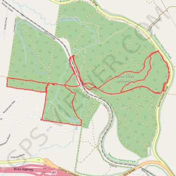
Name: Yurol State Forest Loop GPS track, route, trail
Start: Yurol Forest Drive, Pomona, Noosa Shire, Queensland, 4568, Australia (-26.37623 152.88714)
End: Yurol Forest Drive, Pomona, Noosa Shire, Queensland, 4568, Australia (-26.37632 152.88713)
Coordinates: -26.38673 152.86346 -26.37623 152.88884
Other GPS tracks
Click on a GPS track to view route, its statistics and profile.
Yurol State Forest - Yurol Road Crossing
Morning Run
Distance: 10.8 Km • Elevation gain: 146 m • Maximum elevation: 130 m