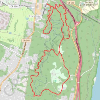
Palisades Interstate Park Mountain Bike Ride
- Distance: 13.7 Km
- Elevation gain: 330 m
- Maximum elevation: 162 m
- Elevation loss: 329 m
- Minimum elevation: 32 m
- Moving time: 1 h 44 m
- Moving speed: 7.9 Km/h
- Maximum speed: 30.7 Km/h
- Total time: 1 h 48 m
- Global speed: 7.6 Km/h
- Date: 23/04/2024
Interactive map
GPS track profile
About this GPS track
Name: Palisades Interstate Park Mountain Bike Ride GPS track, route, trail
Start: Rockleigh Road, Rockleigh, Bergen County, New Jersey, 07647, United States (41.00401 -73.92572)
End: Rockleigh Road, Rockleigh, Bergen County, New Jersey, 07647, United States (41.00406 -73.92561)
Coordinates: 40.97599 -73.93228 41.00406 -73.91654
Other GPS tracks
Click on a GPS track to view route, its statistics and profile.
Rockleigh Woods Sanctuary
United States > New Jersey > Bergen County > Rockleigh
Distance: 11.0 Km • Elevation gain: 325 m • Maximum elevation: 150 m
Alpine & Rockleigh
United States > New Jersey > Bergen County > Alpine
Palisades Interstate Park.
Distance: 15.0 Km • Elevation gain: 309 m • Maximum elevation: 171 m
Montréal - New York
Canada > Québec > Agglomération de Montréal > Montréal
Distance: 637.3 Km • Elevation gain: 4,134 m • Maximum elevation: 301 m