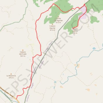
BTT Bardenas 8 - Valdenovillas - Sancho Abarca
- Distance: 33.0 Km
- Elevation gain: 525 m
- Maximum elevation: 622 m
- Elevation loss: 525 m
- Minimum elevation: 255 m
Interactive map
GPS track profile
About this GPS track
Name: BTT Bardenas 8 - Valdenovillas - Sancho Abarca GPS track, route, trail
Coordinates: 41.96678 -1.38184 42.03816 -1.31123
Other GPS tracks
Click on a GPS track to view route, its statistics and profile.
Southern section — European Divide Trail
France > Auvergne-Rhône-Alpes > Drôme > Valence
Distance: 2,423.8 Km • Elevation gain: 42,375 m • Maximum elevation: 2,005 m
Rutas BardenaNegra 7-6
Espagne > Aragon > Erribera / Ribera > Bardenas Reales de Navarra
Distance: 29.4 Km • Elevation gain: 506 m • Maximum elevation: 645 m
BTT Gran Bardena - Extreme Bardenas
Espagne > Erribera / Ribera > Bardenas Reales de Navarra
Distance: 63.7 Km • Elevation gain: 692 m • Maximum elevation: 645 m
Bardenas_Andorre_Mediterranee
Bardenas_Andorre_Mediterranee
Distance: 1,011.0 Km • Elevation gain: 24,504 m • Maximum elevation: 2,214 m
1 LUCENA - MONTPELLIER
Distance: 2,964.4 Km • Elevation gain: 29,500 m • Maximum elevation: 1,048 m
1 LUCENA - MONTPELLIER
Espagne > Andalousie > Lucena
Distance: 2,964.4 Km • Elevation gain: 29,500 m • Maximum elevation: 1,048 m
Stage 26: Valence to Saint-Jean-de-Fos — European Divide Trail
France > Auvergne-Rhône-Alpes > Drôme > Valence
Distance: 2,423.8 Km • Elevation gain: 42,375 m • Maximum elevation: 2,005 m
Kiki Jour 2
Espagne > Aragon > Cinco Villas > Tauste
Distance: 142.6 Km • Elevation gain: 2,343 m • Maximum elevation: 813 m
Stage 26: Valence to Saint-Jean-de-Fos — European Divide Trail
France > Auvergne-Rhône-Alpes > Drôme > Valence
Distance: 1,629.8 Km • Elevation gain: 30,841 m • Maximum elevation: 2,005 m
De Villeneuve-sur-Lot à Guimarães
France > Nouvelle-Aquitaine > Lot-et-Garonne > Villeneuve-sur-Lot
Distance: 2,024.3 Km • Elevation gain: 22,121 m • Maximum elevation: 1,339 m
Tracé
Espagne > Erribera / Ribera > Fustiñana
Distance: 60.8 Km • Elevation gain: 679 m • Maximum elevation: 645 m