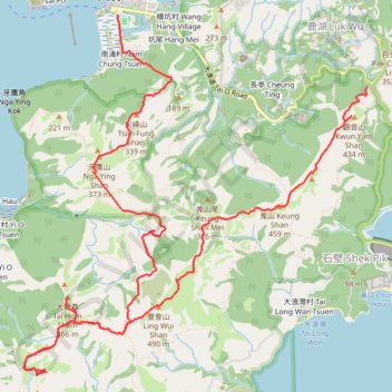
深坑瀝小路
- Distance: 16.6 Km
- Elevation gain: 726 m
- Maximum elevation: 462 m
- Elevation loss: 986 m
- Minimum elevation: -4 m
- Moving time: 4 h 55 m
- Moving speed: 3.4 Km/h
- Maximum speed: 9.4 Km/h
- Total time: 6 h 47 m
- Global speed: 2.4 Km/h
- Date: 15/04/2024
Interactive map
GPS track profile
About this GPS track
Name: 深坑瀝小路 GPS track, route, trail
Coordinates: 22.21395 113.85236 22.25202 113.89135
Other GPS tracks
Click on a GPS track to view route, its statistics and profile.
2024 4TUL Half Loop Final
China > Hong Kong > Tsuen Wan District > Chuen Lung Village > Chuen Lung Cha Tau Wo
Distance: 89.0 Km • Elevation gain: 2,267 m • Maximum elevation: 535 m