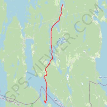
Nicolas_Vanvyve_2021-08-31
- Distance: 19.0 Km
- Elevation gain: 48 m
- Maximum elevation: 120 m
- Elevation loss: 68 m
- Minimum elevation: 94 m
Interactive map
GPS track profile
About this GPS track
Name: Nicolas_Vanvyve_2021-08-31 GPS track, route, trail
Start: DANO34, S 506, Kultarönningen, Årjängs kommun, Comté de Värmland, Suède (59.36775 12.00864)
End: Spargott, Bengtsfors kommun, Comté de Västra Götaland, Suède (59.22588 11.95761)
Coordinates: 59.22468 11.95453 59.36775 12.00864
Other GPS tracks
Click on a GPS track to view route, its statistics and profile.
Stage 1: Arctic Ocean to Väylä — European Divide Trail
Distance: 2,785.0 Km • Elevation gain: 23,823 m • Maximum elevation: 722 m
Nicolas_Vanvyve_2021-09-01
Suède > Comté de Västra Götaland
Distance: 20.3 Km • Elevation gain: 31 m • Maximum elevation: 115 m